Benoa Channel Depths and Approach Notes for Visiting Yachts
The Benoa channel is the deepest marked water on Bali’s south-east coast: a dredged fairway maintained for cruise ships and commercial traffic, opening off the Badung Strait and running between drying reef flats into Benoa Harbour. For a visiting yacht the practical read, as of 2026, is this — the ship channel itself carries depth to spare for any pleasure vessel afloat, the hazards sit either side of it, and the variables that actually decide your approach are tide, cross-set, swell direction and traffic, not the charted figure in mid-channel. This note collects the approach information captains ask our desk for most, and where the adjacent Serangan lagoon entrance fits alongside it.
A note on who is writing: kurakuramarina.com is an independent information and marine-services platform covering the Serangan–Benoa yachting scene. We are not the port authority, and nothing here replaces up-to-date charts, Notices to Mariners, or your own judgement as skipper. Dredging cycles and buoyage in this corner of Bali change; verify the current controlling depth with your agent or the harbour office before you commit a deep-draft hull.
Where the Channel Runs
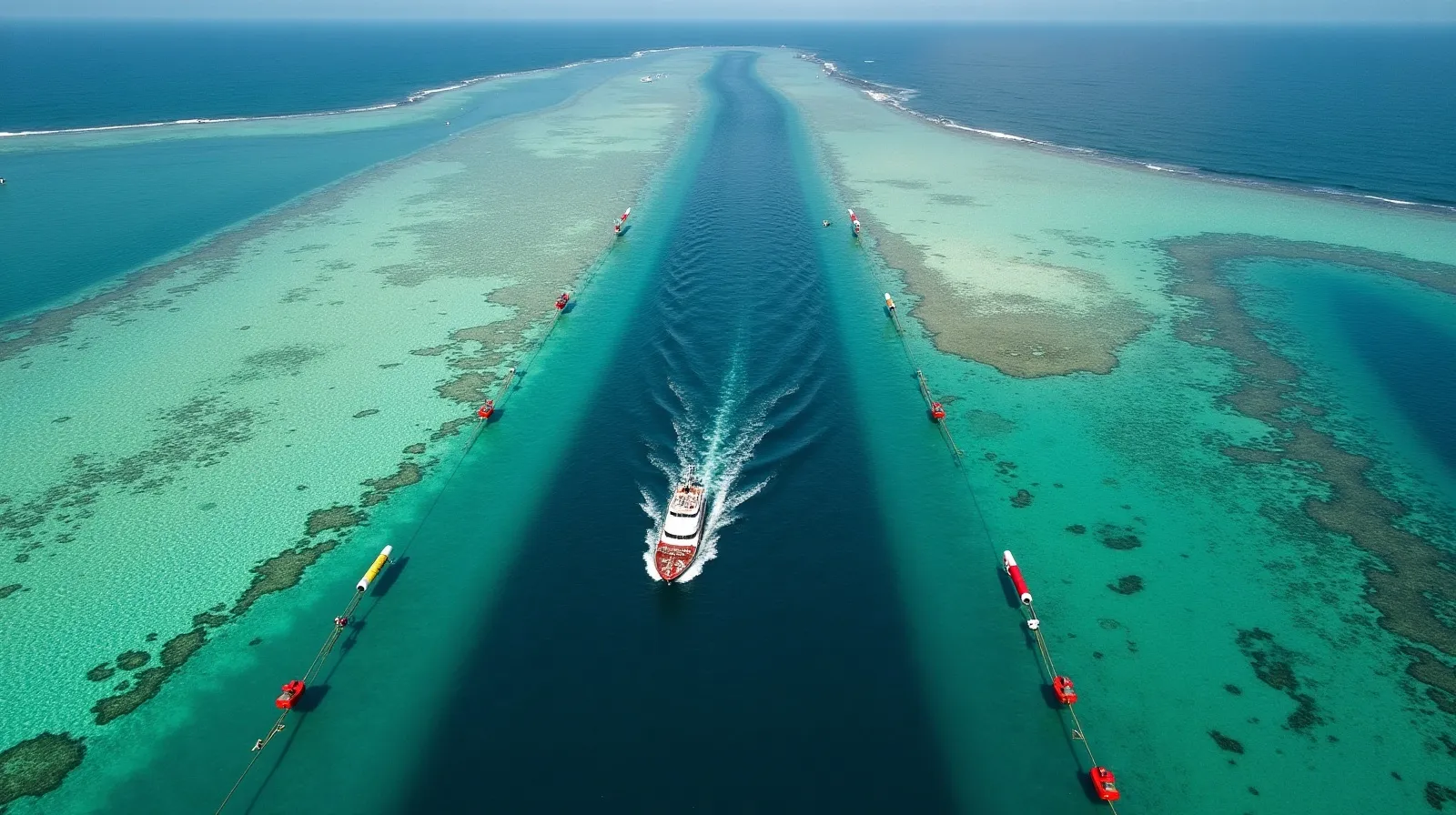
Benoa Harbour occupies the bight on the eastern shore of Bali’s southern isthmus, sheltered behind Serangan Island and the reef line that fronts it. The approach comes up from the south through the Badung Strait, then turns into the marked fairway that cuts through the reef shelf toward the port basin. Two separate entrances serve this stretch of coast and it matters not to confuse them: the commercial Benoa fairway, buoyed and dredged to ship standards, and the smaller buoyed cut on Serangan’s eastern side that serves the lagoon and the marina waterfront. Yachts bound for a Benoa berth use the ship channel; yachts bound for Serangan use the lagoon cut, covered in detail in our Serangan entry guide.
Outside the dredged water the shelf is genuinely shallow — natural depths over the reef flats fall to a metre or less at low water springs, and the fringing reef east of Serangan breaks in any swell. The safe water is the channel, full stop. This is not a coastline for cutting corners on a rhumb line.
Depths: What to Plan On
The commercial fairway is maintained for cruise and cargo tonnage, which in practice means controlling depths well beyond yacht drafts — the port has berthed cruise ships drawing seven metres and more. The honest caveats are at the edges of that statement:
- Controlling depth is a maintained figure, not a law of nature. Dredging campaigns and shoaling between them move the number, especially at the channel margins. The mid-channel figure is not the depth two boat-lengths off the line.
- Inside the harbour, depths vary sharply by berth. The yacht corner of the basin and its approaches are shallower than the cruise wharves; allocation against your draft is part of the berth conversation, which is why we log draft alongside LOA and beam on every berth request.
- Over at Serangan, the existing marina basin is shallow-draft, tide-sensitive water — deeper-keeled vessels time entries with the tide. The full picture, including what the Kura Kura Bali build-out implies for dredged depths, is in our water depth explainer.
Approach Notes, South to North
Coming up the Badung Strait, the sequence experienced captains run looks like this:
- Stand off until the marks are identified. Pick up the outer fairway buoys visually and on the plotter before turning in. Charted detail here lags reality; where chart and buoy disagree, trust the buoy and the water you can read.
- Mind the cross-set. The strait carries real tidal current, hardest around springs, and it runs across the approach as often as along it. Settle on a track over the ground early and watch the transit, not the compass.
- Time the swell. South-east trades from roughly June to September push swell up the strait; it stands up where the shelf shoals. A flooding tide flattens the worst of it and gives a deep hull margin over any shoaling at the edges.
- Listen before you enter. Cruise arrivals, fuel barges, ferries and pilot movements use the same fairway. Monitor VHF 16 and the port working channel from well out; a ship constrained by her draft in a dredged cut has nowhere to give way to.
- First arrival in daylight. Reef edges, buoyage and local traffic — fishing boats, dive tenders, turtle-tour craft — are all far easier to read with the sun up. Night arrival is workable for a return visit; we cover the specifics separately.
Season and Timing
The channel is usable year-round, but comfort moves with the monsoon. The dry-season trades (April to October) bring the reliable south-easterly and its swell; the wet season swings the wind north-west and can make the strait squally but often leaves the approach itself gentler. Slack water or the young flood remains the easiest entry on any given day — our month-by-month season guide sets the wider weather context, and berth demand follows the same calendar, which is why we keep a separate note on how the booking year actually fills.
The Port Is Changing Around You
Benoa is mid-transformation under the Bali Maritime Tourism Hub programme: reclamation, new cruise infrastructure and re-drawn berth allocations, summarised in our Benoa port status report. For pilotage the consequence is simple — construction traffic in the fairway, work areas that move, and layouts that differ from year-old chart editions. Across the bay, the same growth is pulling charter traffic through the season: fleets such as Komodo Luxury’s charter boats stage out of South Bali before repositioning east for the Komodo season, and their movements share this water with you. It is one more reason the radio watch matters more here than the echo sounder.
Once inside, the working facilities — berths, fuel point, slipways and the yard trades — are covered in our Benoa marina and boatyard guide.
How deep is the Benoa channel?
It is maintained to commercial ship standards — cruise vessels drawing seven metres and more use it — so the fairway itself carries ample depth for any yacht. The maintained figure moves with dredging cycles and shoaling at the margins, so deep-draft captains should confirm the current controlling depth with their agent or the harbour office rather than rely on a charted number.
Can a yacht use the Benoa ship channel?
Yes — it is the standard approach for yachts taking a berth at Benoa. The obligations that come with it are a listening watch on VHF 16 and the port working channel, staying clear of commercial traffic constrained by draft, and keeping strictly inside the marks, because the reef shelf either side dries at low water springs.
Is the Serangan entrance the same channel?
No. Serangan’s lagoon and marina waterfront are served by a separate, smaller buoyed cut through the reef on the island’s eastern side. It is shallower, tide-sensitive and has its own pilotage sequence, which we cover in a dedicated Serangan lagoon entry guide.
When is the easiest time to make the approach?
Daylight, on slack water or a young flood, outside the peak of the south-east trade swell. In practice that means a morning entry in the dry season, timed against the tide tables. First-time arrivals at night are not recommended: reef edges, buoyage and small-craft traffic are all much harder to read.
Talk to our yacht desk
Planning a Benoa or Serangan arrival? Send your draft, LOA and dates and we confirm the current channel and berth picture in writing, in USD, with clearance and berthing handled on one WhatsApp thread.